

As climate-related risks become more material to business operations, investment decisions, and regulatory compliance, organisations are turning to climate intelligence platforms to assess and manage their exposure.
These platforms offer data-driven insights into how physical climate hazards, such as flooding, heat stress, and extreme wind, could impact assets, portfolios, and supply chains over time.
Two providers in this space are EarthScan, Mitiga Solutions’, integrated climate intelligence platform, and RiskThinking.ai, offering a modular suite of tools: VELO® App, VELO® Data, and CDTexpress.
While both aim to support climate risk analysis, they differ significantly in platform maturity, scientific transparency, and pricing flexibility.
This guide compares the two offerings to support decision-makers in sustainability, risk, finance, and strategy, who are evaluating climate intelligence solutions for their organisation.
Quick summary table: EarthScan vs RiskThinking.ai
Key features comparison
This section compares how EarthScan and RiskThinking.ai’s product suite approach 8 critical dimensions of climate intelligence. Each feature is explained in terms of its relevance to decision-making, followed by a side-by-side analysis.
1. Hazard types and scenario coverage
Hazard coverage determines the types of physical climate events a platform can model, such as flooding, heatwaves, or extreme wind. Scenario coverage reflects the climate futures considered, typically based on IPCC pathways (e.g. SSPs), which influence the severity and likelihood of those hazards.
Together, these determine how comprehensive and decision-useful a platform’s risk assessments are.
How EarthScan approaches it
- Models 11 hazards across 6 categories. These include:
- Heat: heatwave, heat stress, changing temperature
- Flooding: coastal, fluvial, sea level rise
- Wildfires
- Extreme wind: storm (blizzards)
- Drought: Consecutive dry days
- Precipitation risk: heavy precipitation, hail (US & Europe only)
- Heat: heatwave, heat stress, changing temperature
- Uses 3 IPCC-aligned scenarios:
- SSP1-2.6 (Paris-aligned, <2°C)
- SSP2-4.5 (moderate, 2–3°C)
- SSP5-8.5 (business-as-usual, >3°C)
- Applies scenarios across near-term, mid-century, and end-of-century timeframes, allowing users to assess both short-term and long-term risk trajectories.
- Provides hazard-specific outputs with return periods and uncertainty ranges.

How RiskThinking.ai compares
- Offers projections across 50+ climate hazards, delivered as probability distributions.
- Hazards include floods, wildfires, cyclones, extreme precipitation, and more.
- Supports “all IPCC scenarios” across 15 time horizons (2025–2100). SSPs are not specified.
- All return periods, from frequent to rare extremes.
- Does not publicly disclose uncertainty quantification.
2. Scientific rigour and modelling approach
The scientific foundation of a climate intelligence platform determines the credibility, transparency, and reliability of its outputs.
This includes the climate models used, the statistical methods applied, and how uncertainty is handled.
Platforms built on peer-reviewed science and robust methodologies are better suited for regulatory reporting, strategic planning, and investment-grade risk analysis.
How EarthScan approaches it
EarthScan is built on the same climate models and methodologies used by leading research institutions and the IPCC. It combines:
- CMIP6 global climate models
- CORDEX regional datasets
- ERA5 reanalysis data
- Observational data from over 100,000 weather stations
- Remote sensing and satellite retrievals
At the core of EarthScan is the Multiple Futures Model (MFM), a proprietary probabilistic framework that simulates a full range of plausible climate futures. MFM uses Bayesian inference to combine historical data, model outputs, and expert knowledge, delivering probabilistic risk estimates with confidence intervals.
EarthScan also applies Gaussian Process Regression (GPR) to fill data gaps and quantify uncertainty, especially in regions with limited observations. This ensures that risk assessments are both scientifically defensible and locally relevant.
Bias correction is performed using quantile-based adjustment methods, aligning model outputs with observed climatology. Validation is continuous and includes statistical checks, differential mapping, and scientific review.
Together, these methods provide a rigorous, transparent, and adaptive modelling approach that supports regulatory compliance and strategic decision-making.
How RiskThinking.ai compares
- Uses a stochastic simulation engine called the Climate Digital Twin™ (CDT™).
- Applies probabilistic modelling to assess tail risks and scenario distributions.
- Scientific methodology (e.g. climate models, statistical techniques) is not publicly disclosed.
- No confirmation of ensemble modelling, Bayesian inference, or machine learning methods.
3. Resolution and geographic coverage
Resolution refers to the spatial granularity of climate hazard data. High-resolution data enables more precise asset-level risk assessments, while geographic coverage determines how globally applicable the platform is.
How EarthScan approaches it
EarthScan offers hazard-specific resolution ranging from 90 metres to 25 kilometres:
- Riverine flood: 90 m
- Coastal flood: 130 m
- Wildfire: 25 km with 500 m flammable area mask
- Heat stress, wind, drought, hail, and precipitation: 25 km
The platform supports global coverage and is designed for both portfolio-level screening and asset-level decision-making. Its downscaling techniques ensure local relevance across geographies.
How RiskThinking.ai compares
- Describes projections as “high-resolution” but does not specify resolution metrics.
- Covers 193 countries and 241 billion global locations.
- Supports analysis of 6M+ physical assets and 13K listed companies.
4. Risk quantification and tail-event planning
Risk quantification involves translating hazard exposure into financial metrics, such as damage estimates or return periods. Tail-event planning refers to modelling rare but high-impact events, which are critical for stress testing and resilience planning.
How EarthScan approaches it
EarthScan provides return periods for all hazards at six standard intervals (2, 5, 10, 20, 50, 100 years) and extended intervals (200 to 1,000 years) for wind and wildfire. It also offers Climate Value at Risk (CvAR) and full uncertainty quantification using Bayesian inference.
These metrics support regulatory stress testing and long-term financial planning.
How RiskThinking.ai compares
- Offers expected loss, tail risk analytics, and probability of adverse outcomes.
- Damage projections expressed as a percentage of property replacement value.
- No publicly disclosed CVaR metrics.

5. Climate data outputs and decision usefulness
Climate intelligence platforms must deliver outputs that are interpretable, actionable, and aligned with decision-making workflows. These include maps, scores, indices, and scenario-based projections.
How EarthScan approaches it
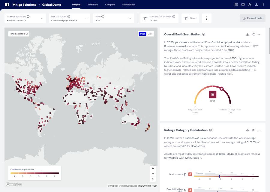
EarthScan provides continuous climate data from 1970 to 2100 in five-year increments. Outputs include:
- Composite risk scores
- Scenario filtering tools
- Hazard-specific indices
- Asset-level ratings
- Risk trajectories (how the risk will evolve over time)
These outputs are designed to support due diligence, location planning, operational efficiency, and physical climate risk reporting.
How RiskThinking.ai compares
- VELO App provides interactive mapping, benchmarking, and scenario simulation.
- VELO Data offers machine-readable datasets across hazards, assets, and risk analytics.
- CDTexpress enables custom modelling via API and Jupyter Notebooks.
- Outputs include expected loss, hazard attribution, and productivity loss.
6. Reporting and disclosure readiness
Climate risk platforms must support alignment with frameworks like TCFD, CSRD, and ISSB to ensure auditability and regulatory compliance.
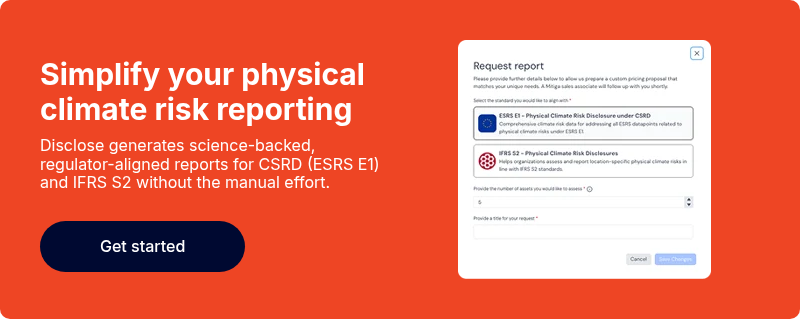
How EarthScan approaches it
Mitiga Solutions’ Disclose is a specialised module designed to automate and simplify physical climate risk reporting. It supports alignment with:
- ESRS E1 (CSRD)
- IFRS S2, including jurisdictional implementations like California SB 261 and Australia’s AASB S2
- TCFD-aligned frameworks
Users can upload asset data and receive a complete, science-backed physical climate risk report within minutes. The outputs include:
- Interactive climate risk profiles by location and hazard
- Financial exposure estimates under multiple scenarios and timeframes
- Auto-generated narrative language aligned with disclosure standards
- Excel-based, submission-ready reports tagged to ESRS datapoints
How RiskThinking.ai compares
- No public confirmation of alignment with CSRD, TCFD, ISSB, or other regulatory frameworks.
- VELO App and CDTexpress offer data visualisation and API access, but reporting capabilities are not described.
- No evidence of automated disclosure outputs or regulatory tagging.
7. Commercial model and pricing flexibility
Pricing affects accessibility and scalability. Flexible models allow organisations of different sizes to adopt climate intelligence tools without prohibitive costs.
How EarthScan approaches it
EarthScan offers tiered pricing. There are no minimum contract requirements, and discounts are available for API customers. Pricing is designed to be accessible and scalable, especially for organisations with large asset portfolios or existing tech infrastructure.
How RiskThinking.ai compares
- CDTexpress offers volume-based, usage-driven pricing.
- VELO Data and VELO App pricing not publicly disclosed.
- No minimum contract terms confirmed.
8. Platform speed and usability
Usability and responsiveness are critical for adoption. Platforms should offer intuitive interfaces, fast data delivery, and integration options for enterprise workflows.
How EarthScan approaches it
EarthScan is a fully operational SaaS platform with a scalable API capable of handling over 3.5 million calls per month. It supports instant results, custom location uploads, and seamless integration into client workflows.
How RiskThinking.ai compares
- VELO App offers real-time scenario analysis, asset uploads, and mapping tools.
- CDTexpress provides fast, scalable API access with ready-to-use notebooks.
- Platform performance benchmarks are not publicly disclosed.

EarthScan vs Riskthinking.ai: Which one to choose?
Choosing the right climate intelligence platform depends on your organisation’s goals, regulatory obligations, and internal capabilities. While both EarthScan and RiskThinking.ai aim to support climate risk analysis, they differ significantly in platform integration, scientific transparency, and readiness for operational deployment.
EarthScan is a fully operational, unified platform. It offers high-resolution, asset-level risk assessments, probabilistic modelling, and full uncertainty quantification.
With support for custom location uploads, scalable API integration, and alignment with regulatory frameworks, EarthScan is designed for organisations seeking a transparent, audit-ready solution for both capital allocation planning and disclosure.
RiskThinking.ai, by contrast, provides a modular suite of tools, VELO App, VELO Data, and CDTexpress, built around its Climate Digital Twin™ simulation engine. These tools offer probabilistic hazard projections, tail-risk analytics, and flexible data delivery.
However, the scientific methodology behind the platform is not publicly disclosed, and there is no confirmed alignment with regulatory frameworks such as TCFD or CSRD. While VELO App supports real-time scenario analysis and asset uploads, the overall platform experience is distributed across separate products.
For decision-makers evaluating climate intelligence solutions:
- Choose EarthScan if you need a ready-to-use, scientifically rigorous platform that supports compliance, operational decision-making, and enterprise integration.
- Consider RiskThinking.ai if your organisation has mapped public assets and can accommodate a modular setup with internal modelling capabilities.
Ultimately, the choice depends on whether you value a unified, disclosure-ready platform or a flexible, data-driven toolkit for financial climate analytics.
Final words
EarthScan and RiskThinking.ai represent two distinct approaches to climate intelligence. EarthScan delivers a unified, science-backed platform with regulatory-ready outputs, while RiskThinking.ai offers modular tools tailored to financial analytics.
If you're comparing climate risk platforms, make sure you're asking the right questions. Read our piece on what to consider when choosing a climate risk platform to guide your evaluation.
Ready to see how EarthScan performs in real-world decision-making? Book a demo today and discover how Mitiga Solutions can help you turn climate risk into strategic advantage, whether you're preparing disclosures, assessing exposures, or building resilience.
