

If you’re evaluating climate risk platforms to support investment planning, regulatory reporting, or resilience strategies, you’ve likely come across tools like EarthScan (by Mitiga Solutions) and Spectra (by Climate X).
Both offer hazard-level climate risk insights and intuitive user experiences, but they have been designed for different users and use cases.
- EarthScan is built for organisations that need science-based, decision-ready insights to support climate disclosures, due diligence, and high-stakes investment decisions at both asset and portfolio level.
- Spectra is used to visualise physical climate risks and explore high-level adaptation strategies, particularly by financial institutions in the UK and Europe, where flood modelling is a core focus.
This side-by-side comparison covers pricing, hazard coverage, methodology, regulatory alignment and usability to help you decide which platform fits your business needs best.
Quick summary table: EarthScan vs Spectra
Here’s how the two platforms compare across key features, from scientific models to pricing and regulatory fit.
EarthScan vs Spectra: Key feature comparisons
This section breaks down the capabilities that matter most when evaluating climate risk platforms from scientific accuracy to reporting speed.
For each feature, we explain how EarthScan and Spectra compare, so you can choose what’s right for your business.
1. Platform speed and usability
When deadlines are tight, whether you're preparing a board report, submitting a CSRD disclosure, or evaluating risk ahead of a transaction, speed and usability matter.
How fast you can upload, analyse, and share insights is often the difference between meeting a deadline or missing it.
How EarthScan approaches it
EarthScan is a self-serve platform designed for speed and simplicity:
- Users can upload asset lists via CSV or search from a global database of 500M+ existing locations. No need to manually input coordinates.
- Asset-level insights are generated in seconds, with no need for external consultants or manual formatting.
- The interface is clean and responsive, built for users who need fast answers without the clutter, from consultants and risk managers to sustainability and operations teams.
- Includes instant report generation. Users can download PDF or Excel summaries aligned to CSRD, TCFD or ISSB in just a few clicks.
Energy firms use EarthScan to evaluate dispersed infrastructure across multiple countries, quickly switching between assets, time horizons, and climate scenarios. All from one dashboard.
How Spectra compares
Spectra offers a visual-first interface that’s often compared to Google Maps. It allows users to click through assets and explore climate risk overlays interactively, a format that can work well for early-stage exploration or executive presentations.
That said, Spectra appears more tailored to single-asset workflows than portfolio-wide analysis:
- Users can input addresses manually or upload asset lists in CSV format; APIs are also available for integration.
- Risk scores and adaptation data are generated per asset, with configurable parameters like climate scenario and asset use.
- There is no mention of batch-level report generation, automated disclosure exports, or support for multi-asset reporting workflows.
This approach may suit advisory teams focused on one-off risk exploration, but may be less efficient for high-volume assessments or regulatory reporting.
2. Scientific foundations and modelling approach
The credibility of climate risk insights depends on the science underneath.
From which climate models are used to how projections are validated, these choices determine whether your data can stand up to scrutiny, especially under investor, auditor, or regulator review.
How EarthScan approaches it
EarthScan is built on transparent scientific methodology. The platform combines:
- CMIP6 climate models, aligned with the IPCC's latest reports
- Regional datasets like CORDEX for downscaled precision
- ERA5 reanalysis and NASA GDDP for long-term historical context
- A Bayesian statistical framework that quantifies uncertainty using 5th, 50th, and 95th percentiles, providing a clearer picture of best, average, and worst-case scenarios
- Bias correction using satellite retrievals, remote sensing, and over 100,000 weather stations
- Continuous model validation pipelines to ensure scientific reliability and audit-readiness
EarthScan is developed by scientists at Mitiga Solutions, a company founded as a spin-off from Spain’s National Supercomputing Center. More than 40% of the team hold PhDs, a reflection of Mitiga’s origin in climate science, not software sales.
Mitiga prides itself on not compromising the rigour of its science and technology. This foundation enables EarthScan to translate climate variability into actionable insights, backed by models that can stand up to investor, auditor, and regulatory scrutiny.
For infrastructure investors and financial institutions in particular, this level of scientific rigour provides confidence that risk insights can be defended in investment memos, due diligence reports, and disclosures.
How Spectra compares
Spectra is built on CMIP5 climate models, which were widely used in earlier IPCC reports but are gradually being replaced by more recent datasets like CMIP6. The platform also draws on remote sensing and public databases, and mentions the involvement of a modelling risk expert and third-party validation.
According to their website, Climate X states that their models are "peer-reviewed by industry experts" and "fully validated," achieving up to 99% accuracy across various hazards.
However, detailed technical documentation or peer-reviewed publications are not currently shared online, which may make it harder for users to fully understand the assumptions behind the outputs.
Spectra also highlights its focus on adaptation planning through features like CapEx and ROI estimates. These are positioned as useful tools for exploring the cost-effectiveness of resilience measures, particularly in sectors like banking or real estate.
3. Hazard types and scenario coverage
Understanding what hazards are modelled, and under which future climate scenarios is foundational to evaluating and acting on climate risk.
Whether you're making long-term investment decisions, planning infrastructure upgrades, or evaluating portfolio exposure, the specific hazards and scenarios available in a platform directly shape how useful and relevant the outputs will be.
How EarthScan approaches it
EarthScan models a targeted set of high-impact climate hazards aligned with regulatory and investment risk priorities:
- Heatwave
- Heat stress
- Changing air temperature
- Drought
- Storm
- Heavy precipitation
- Coastal flooding
- Sea level rise
- Fluvial flooding
- Wildfire
- Hail
- Pluvial flooding is currently in development and expected soon
When needed, hazards are combined into a composite risk score, especially useful for screening portfolio-level risk exposure.
Future climate risks are modelled under 3 IPCC-aligned scenarios:
- SSP1 (Paris-aligned)
- SSP2 (intermediate)
- SSP5 (business-as-usual / worst case)
Scenario outputs are available in 5-year increments from 1970 to 2100, making it easy to monitor shifts in risk over time and across investment horizons.
Crucially, EarthScan allows users to select from a wide range of return periods, from 2 to 1,000 years, for all hazards, with extended options for perils like wind and wildfire.
This flexibility helps users evaluate both frequent and extreme events across time horizons, supporting use cases like stress testing, risk-based pricing, and long-term capital planning.
It’s especially valuable for sectors managing long-lived physical assets, such as infrastructure, real estate, and energy, where understanding tail-risk exposure is critical to resilience and compliance.
Return periods refer to the average frequency at which a given intensity of climate hazard is expected to occur. For example, a 100-year flood has a 1% chance of occurring in any given year.

How Spectra compares
Spectra models several hazards, including flooding (coastal, riverine, surface), subsidence, landslide, tropical cyclones, and storm surge, offering broad hazard visibility.
It also includes 8 scenarios (a mix of RCPs and SSPs), giving users flexibility in selecting climate futures. Scenario increments are provided every 5 years up to 2050, shifting to 10-year intervals thereafter.
While the breadth of hazards is a strength, you should be aware that:
- Combined or composite risk scores are not currently available, which may require manual consolidation when assessing exposure across portfolios
- Outputs may require additional interpretation or post-processing to align with regulatory frameworks like CSRD or ISSB
This makes Spectra well-suited for visual exploration and high-level scenario analysis, but may require extra steps for use in portfolio-scale reporting or compliance workflows.
4. Resolution and geographic coverage
When assessing physical risk, detail matters.
Spatial resolution determines how precisely a tool can capture risk at the asset level, and geographic coverage dictates whether those insights are available where your assets are.
How EarthScan approaches it
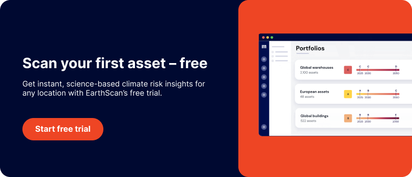
EarthScan provides high-resolution, location-specific insights for assets worldwide:
- Resolution varies by hazard, including:
- 90m for riverine flooding
- 130m for coastal flooding
- 25km for wind, heat stress, drought, wildfire and precipitation
- Outputs are available for any point on land, including Europe, North America, LATAM, APAC, Africa and the Middle East
EarthScan also includes:
- 500M+ pre-mapped assets, allowing users to run risk assessments without uploading coordinates manually.
- Support for asset-level and portfolio-level views, particularly useful in real estate, energy, and financial services.
For example, commercial real estate firms can evaluate structural exposure in dense urban areas, while energy clients use EarthScan to assess distributed assets across regions with varying hazard profiles.

How Spectra compares
Spectra provides access to a large mapped asset base, estimated at 1.5 billion assets, with strong coverage in the UK, Europe, and North America.
Its visual-first interface is designed for map-based exploration, which can work well for consultants conducting targeted, one-off assessments.
This approach works well for individual asset exploration, though it’s worth noting some limitations at scale:
- Hazard coverage is most complete in Europe and North America; data depth in APAC, LATAM, the Middle East, and Africa is not available
- Spatial resolution per hazard type is not publicly disclosed
Climate X does not publicly disclose support for features like composite risk scoring or batch-level downloads, which may require additional manual processing or tool integration for users managing high-volume or cross-regional portfolios.
If your organisation is managing global assets or conducting deep portfolio analysis, this may add steps to your workflow depending on your specific use case.
5. Risk quantification and tail event planning
For companies managing long-term assets, from real estate portfolios to investment due diligence, planning for low-probability, high-impact events is non-negotiable.
The ability to model climate hazards using a range of intensities and probabilities, not just expected values, is a key differentiator in climate intelligence platforms.
How EarthScan approaches it
EarthScan was designed to support data driven decision-making, with features that go beyond surface-level insights:
- Offers customisable return periods from 2 to 1000 years, covering both frequent and extreme events
- Uses a Bayesian statistical framework to model probability distributions, enabling tail-risk quantification that reflects future volatility
- Provides 90% confidence intervals across all hazards, helping teams understand uncertainty and plan around it
- Includes Climate Value at Risk (CVaR) metrics for hazards like flood and wind, translating physical risk into estimated financial damage
The CVaR is an estimate of the potential financial impact of climate-related hazards on assets.
This capability is especially valuable for infrastructure and insurance clients that need to test asset resilience under rare but severe climate stressors.

Quantifies the average loss over a specific time period of unlikely scenarios beyond the confidence level.
How Spectra compares
Spectra provides basic probability indicators for hazard exposure, such as a general “likelihood” score, along with some stated accuracy percentages (e.g. 65–75%) for selected hazards.
These may support initial risk screening or portfolio triage, particularly in familiar markets.
However, the platform does not currently support:
- Customisable return periods — all hazards are limited to a standard 100-year return period
- Tail-risk quantification or scenario-based stress testing using percentiles or probabilistic distributions
- CVaR (Climate Value at Risk) metrics or other financial damage estimates
It also does not surface hazard intensity values, such as flood depth or wind speed, which are often critical for assessing exposure severity.
This limits its application for users needing to model high-impact, low-frequency events, such as infrastructure investors, insurers, or sustainability leads conducting regulated risk assessments.
In those contexts, understanding uncertainty ranges and return-period sensitivity is often essential.
6. Climate data outputs and decision-usefulness
Climate risk platforms should do more than visualise threats, they should deliver clear, decision-ready outputs that inform strategy, operations, and disclosure.
The way raw data is processed, presented, and contextualised makes all the difference.
How EarthScan approaches it
EarthScan translates raw climate signals into practical, asset-level insights, built for real-world action:
- Delivers physical risk ratings (A–F) based on projected hazard intensity and historical baselines
- Provides quantitative outputs like CVaR and hazard exposure values
- Exports insights as charts, maps, and downloadable reports (PDF or Excel), aligned to reporting and planning formats
- Enables users to track risk through time, across scenarios, and by asset or portfolio, supporting prioritisation and internal decision flows
- Built with decision-makers in mind, not just climate scientists or technical analysts
Clients in real estate and finance use these outputs to inform refinancing decisions, capital improvement plans, and M&A screening.

How Spectra compares
Spectra’s strength lies in its visual-first interface, which presents climate hazard data through interactive maps, overlays, and asset-level risk indicators.
This can support early-stage exploration, particularly for asset-specific discussions or internal presentations.
That said, you may find limitations in terms of structured outputs:
- Risk insights are primarily visual, with less emphasis on numeric scoring or benchmarks
- There is no composite or multi-hazard risk score to simplify comparisons across assets or regions
- Export options and report generation workflows are not publicly documented, and there is no support for regulatory alignment or auto-generated outputs
- The Adapt module provides high-level CapEx and ROI estimates for adaptation options, but is not designed for financial modelling or integration into ESG reporting systems
While Spectra may suit advisory teams conducting one-off asset reviews or high-level screening, it may require additional work to integrate insights into portfolio-level planning, compliance reports, or decision frameworks.
7. Reporting and disclosure readiness
With CSRD, ISSB, and SEC climate regulations now in force or coming soon, climate risk platforms need to do more than visualise data.
They need to help you save time, reduce manual effort, and generate clear, audit-ready disclosures that meet regulatory expectations.
How EarthScan approaches it
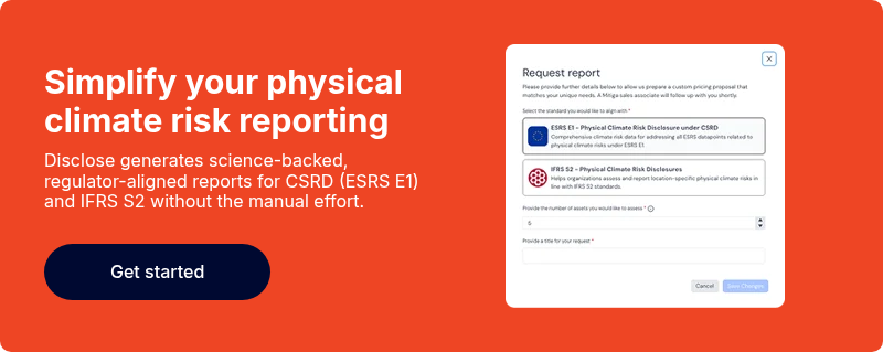
EarthScan Disclose is a reporting-ready product designed to help companies meet regulatory requirements like CSRD, TCFD, and ISSB with confidence. It maps physical risk data directly to ESRS E1 datapoints (Article 15), including:
- Hazard exposure and probabilities
- Return periods and financial impact estimates
- Pre-filled disclosure narratives and visual summaries
Reports are generated instantly in Excel or PDF, saving your team time while ensuring outputs are regulator and auditor -ready.
Customisation options allow consultants and in-house teams to tailor the content to reflect materiality and business context.
For sustainability leads, consultants, and asset managers facing CSRD deadlines, EarthScan Disclose eliminates the need to interpret raw data or build templates from scratch.

How Spectra compares
Spectra is not positioned as a climate disclosure platform.
While it can support early-stage climate risk awareness, its outputs are not currently mapped to regulatory frameworks like CSRD, TCFD, or ISSB. Automated reporting functionality is also not publicly documented.
Additional considerations include:
- No automated reporting features or pre-formatted outputs for disclosures
- No mapped datapoints for physical risk categories or required ESRS fields
- Export functionality is limited and not designed for regulator-facing or auditor-ready formats
- The platform is better suited for internal visualisation or early-stage scenario analysis than for structured, traceable reporting
For companies with upcoming CSRD deadlines or ISSB requirements, this could create extra manual work or require supplementing Spectra with additional tools for compliance.
8. Commercial model and pricing flexibility
Choosing a climate platform isn’t just about features, it’s also about fit.
For many companies, especially consultancies and real estate funds with dynamic portfolios, flexibility in pricing and access is just as important as the data itself.
How EarthScan approaches it
EarthScan offers a tiered pricing model that’s designed to scale with your use case:
- No minimum contract value
- Pricing is per asset, with volume-based discounts
- API access is discounted for clients integrating climate risk into their existing platforms
- Modular products (like EarthScan Disclose) can be added as needed, reducing overhead for teams focused on specific outputs like CSRD
- Transparent quotes and self-serve trial access are available to speed up procurement
This makes EarthScan well-suited for consulting firms, real estate investors, and infrastructure operators who don’t want to be locked into inflexible contracts.
How Spectra compares
Spectra follows a traditional enterprise pricing model:
- Pricing is not publicly disclosed; full access typically requires direct engagement with their sales team.
- API access is available, but there’s no public information on flexible pricing or integration-specific tiers.
- According to publicly available information, Spectra appears to be offered in predefined packages, which may include asset limits or feature restrictions. Details on customisation and scalability are not clearly disclosed.
- It seems the model is designed for large financial institutions with longer procurement cycles. This can make it less accessible for consultants, sustainability teams, or project-based users looking for more flexibility.
By contrast, EarthScan offers flexible pricing and a reliable, self-serve API built to support both quick asset-level checks and enterprise-scale integration.
How to choose between EarthScan and Spectra
Both EarthScan and Spectra are built to help organisations understand climate risk, but their focus, depth, and usability differ depending on your goals.
Choose EarthScan if you need…
- Global coverage, not just UK and Europe
- Fast, on-demand insights and CSRD-ready reports
- Support for asset-level, portfolio, and decision-making workflows, including compliance, investment planning, and risk mitigation
- Flexible pricing that scales with your project or client base
Choose Spectra if you want…
- A visual-first experience for single-asset flood exploration
- Broad hazard coverage (e.g. subsidence, landslide, storm surge)
- ROI/CapEx planning support via Adapt module
- An interface designed around one-off asset visualisation
Final words
Climate risk is complex, but the right platform should make it easier to act with confidence. Whether you're planning infrastructure investments, preparing for CSRD, or advising clients on risk exposure, how insights are delivered matters as much as the science behind them.
If you're looking for a platform that combines scientific transparency, automated reporting, and fast asset-level insights, EarthScan offers a practical, trusted alternative. It’s already helping sustainability consultants, financial services teams, and infrastructure operators make faster, more informed decisions without the friction of rigid systems or manual workflows.
Curious how it could work for your portfolio? Start a free trial, explore EarthScan with your assets, and see results in minutes, no lengthy setup required.
Prefer a guided walkthrough? Book a demo with one of our experts for a tailored view of how EarthScan compares in your specific context.
