
Trusted by global leaders


Transform complex climate data into defensible decisions
Bridge climate science and business strategy with EarthScan, delivering you clear, consistent, and traceable insights that stand up to internal and external scrutiny.
Scientific insights, simplified
Built on Mitiga’s proprietary Signals Engine, EarthScan combines CMIP6, CORDEX, and Bayesian modelling to provide science-grade accuracy at global scale, powered by supercomputing and AI-enhanced automation.
Financial clarity where it matters
Quantify how climate hazards translate into financial exposure. With Climate Value at Risk (CvAR) and exceedance probabilities, EarthScan links physical risk directly to asset value, pricing and performance.
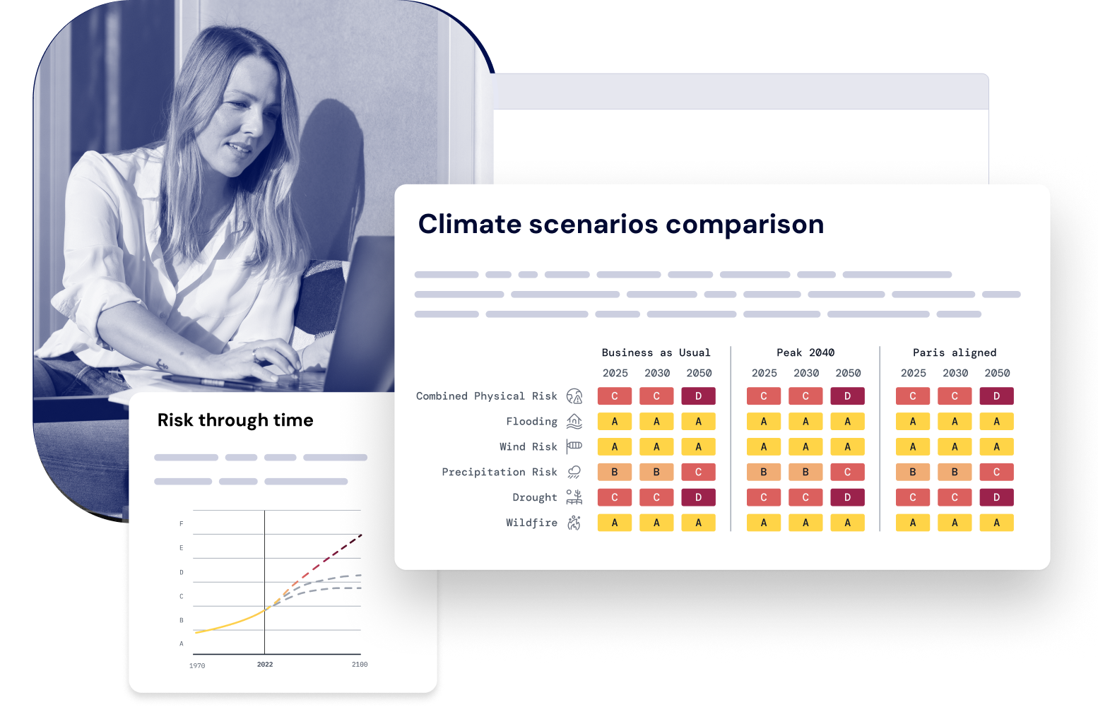
Scalable, scenario-ready analysis
Move from raw data to decisions. EarthScan’s ratings, visual dashboards, and ready-to-share reports turn complex science into clarity for investment, planning, and disclosure.
Actionable intelligence for every decision
Turn complex models into clarity. EarthScan’s ratings, dashboards, and exportable reports translate science into insights your team can act on; creating a single, shared source of climate truth for sustainability, risk, and finance teams.
Aligned with the world’s leading climate and reporting standards


From raw data to actionable insights, in minutes
EarthScan automates your climate risk assessment process, turning raw location data into consistent, defensible results. No modelling expertise required.
Modelled on the hazards that shape real-world risk
EarthScan helps you quantify exposure to the physical climate hazards that matter most for investors, insurers, and asset owners, the ones most frequently disclosed under CSRD, IFRS S2, and TCFD.
Risk Category
EU Taxonomy
EU Taxonomy
ACUTE
Heat wave
CHRONIC
Heat stress
Changing temperature (air)
Business Relevance
Energy demand, worker safety, material expansion
EU Taxonomy
ACUTE
Drought
Business Relevance
Water scarcity, operational downtime, subsidence
EU Taxonomy
ACUTE
Coastal flooding
Fluvial flooding
Pluvial flooding
CHRONIC
Sea level rise
Business Relevance
Drainage overload, erosion, structural wear, building damage, infrastructure loss and coastal retreat
EU Taxonomy
ACUTE
Storm (blizzards)
Cyclone, hurricane and typhoon
Tornado
CHRONIC
Changing wind patterns
Business Relevance
Structural failure, insurance losses, fire/smoke damage, supply-chain disruption
EU Taxonomy
ACUTE
Heavy precipitation
Hail
CHRONIC
Precipitation or hydrological variability
Business Relevance
Drainage overload, erosion, structural wear, building damage, infrastructure loss and coastal retreat
EU Taxonomy
ACUTE
Wildfire
Business Relevance
Structural failure, insurance losses, fire/smoke damage, supply-chain disruption
''EarthScan is a straightforward climate risk analysis tool with a great UX environment. The team is also very supportive and makes sure your needs are met!''

Quantify exposure with scientific accuracy
Powered by over 100,000 weather stations across 180+ countries.
Replace static hazard maps with traceable, validated data
Understand how risk exposure evolves under multiple climate futures
Access projections up to 2100, in 5-year increments

Translate physical risk into financial impact
Climate Value at Risk (CvAR) translates hazard severity into potential loss
Estimate the ROI of adaptation and resilience measures
Reprice risk and inform insurance or investment models
Compare and prioritise where it matters
Uncover risk concentrations, diversification opportunities, and emerging hotspots across portfolios
Support capital planning, resilience investment, risk transfer or divestment based on where exposure and business relevance intersect
Standardised A–F ratings and return periods (2–1,000 years)

From fragmented analysis to scalable automation
Scale analysis from single-site to global portfolio
Standardize risk language across teams using consistent metrics, time horizons and scenarios
Replace weeks of consultant-led reports with automated insights that plug directly into planning and action
Integrate and collaborate seamlessly
Build internal confidence and external credibility
Communicate risk and resilience clearly to boards and investors
Empower non-scientists to make science-based decisions

Trusted by industry leaders
“EarthScan lets us integrate climate risk into every investment decision. It’s not just about compliance, it’s about protecting returns for decades to come.”
Head of ESG at Arjun Infrastructure Partners
portfolio assessed under multiple future climate scenarios

“With EarthScan, we can stress test our assumptions using science-backed data for every asset, across decades. It’s changed how we manage risk.”
ESG Director, Fengate Asset Management
saved per asset on due diligence costs; ~€94,000 annual savings expected

“EarthScan has been a game-changer for Créfinance. It’s allowed us to show clients exactly how climate change could affect their homes and empower them to act”
Owner & Marketing Communication Manager, Créfinance
(flood, drought, wind, wildfire, precipitation, heat stress) assessed for each asset
Award-winning climate intelligence
Frequently asked questions
EarthScan quantifies how physical climate hazards, such as flood, heat, drought, wind, and wildfire, affect your assets and portfolios worldwide. It’s used by organisations that need science-based, defensible data to inform investment, risk, and reporting decisions.
The platform converts complex climate projections into risk ratings, return periods, and financial metrics such as Climate Value at Risk (CvAR). In seconds, you see how hazards could impact asset performance, value, and insurability, so decisions are based on evidence, not assumptions.
Most tools stop at static hazard maps. EarthScan delivers probabilistic, forward-looking insights that are location-specific, financially relevant, and fully traceable, combining CMIP6 and CORDEX datasets with Mitiga Solutions’ proprietary Bayesian modelling for local accuracy and global consistency.
Every output is generated through Mitiga Solutions’ Signals Engine, which refines climate model data using bias correction, downscaling, and validation against 100,000+ weather stations. The result is scientifically defensible, peer-reviewed accuracy you can rely on for regulatory and financial decisions.
Absolutely. Many investors and lenders already use EarthScan during pre-acquisition to evaluate exposure, model downside scenarios, and adjust pricing or deal structure. It helps quantify inherited risk before capital is committed, saving time, cost, and reputational risk later.
Yes. You can export datasets or connect directly via API to your ESG, ERM, or financial platforms. You can also use our climate risk reporting tool, Disclose, to generate CSRD, IFRS S2, and TCFD-aligned reporting, eliminating manual work and audit stress.
Yes. EarthScan aligns with leading global frameworks including CSRD (ESRS E1), IFRS S2, TCFD, EU Taxonomy, GRESB, and CRREM. Outputs are designed to be traceable, comparable, and assurance-ready, giving compliance teams confidence in every submission.
EarthScan models hazard data for 180+ countries with hazard-specific spatial resolutions down to 90 m. It supports both built and natural assets, from real estate portfolios to renewable infrastructure, industrial facilities, and supply-chain nodes.
You can explore hazard maps, risk ratings, and portfolio insights using a curated dataset. It’s designed to let you experience the full interface and reporting workflow before integrating your own assets. Enterprise plans unlock API access, portfolio uploads, and CvAR analysis.
Simply start a free trial to upload your asset locations via CSV, no engineering setup or modelling expertise required. Within minutes, you’ll see quantified exposure, financial relevance, and climate-adjusted insights ready to share with stakeholders.
If you’d like to see more of the advanced platform, please book a demo.

Turn climate uncertainty into clarity
See how EarthScan translates raw climate data into standardized, decision-ready insights, so you can protect value, meet disclosure requirements, and invest with confidence.
