

If you’re evaluating climate risk platforms for investment decisions, regulatory reporting, or operational risk management, two of the most frequently compared solutions are EarthScan (by Mitiga Solutions) and Jupiter's ClimateScore Global.
Both are positioned as asset-level, science-based solutions for physical climate risk analysis. Both promise granular insights to support portfolios, due diligence, and disclosure workflows.
But their underlying methodologies, delivery models, and outputs take different paths. Understanding those differences is critical when deciding which platform best fits your organisation’s needs, from the hazards covered and modelling approaches used, to how results are visualised, priced, and aligned with regulatory standards like CSRD, TCFD, or ISSB.
Whether you’re managing real estate, infrastructure, or financial portfolios, this guide will help you evaluate both platforms against your business priorities and make an informed decision.
Quick summary table: EarthScan vs Jupiter
Here’s how the two platforms compare across key features, from hazard coverage to regulatory alignment and pricing flexibility.
Key feature comparisons: EarthScan vs Jupiter
Now let’s take a closer look at how EarthScan and Jupiter compare across the features that matter most, from scientific models and hazard coverage to financial metrics, resolution, and disclosure readiness.
1. Hazard types and scenario coverage
The specific hazards and climate scenarios each platform models will shape how useful the outputs are for your organisation’s real assets, investment timelines, and disclosure requirements.
Not all platforms cover the same perils or offer equal flexibility in scenario modelling.
How EarthScan approaches it
EarthScan models a targeted set of high-impact hazards aligned with both regulatory frameworks and investment priorities. As of today, EarthScan includes:
- Heatwave
- Heat stress
- Changing air temperature
- Drought
- Storm (blizzards)
- Heavy precipitation
- Coastal flooding
- Sea level rise
- Fluvial flooding
- Wildfires
- Hail
Pluvial flooding is in development and expected to be available soon. Additional hazard expansions, including hail, hydrological variability, tornadoes and cyclones, are also underway.
EarthScan models future climate risks under 3 IPCC-aligned scenarios:
- SSP1 (Paris-aligned)
- SSP2 (Emissions peak in 2040)
- SSP5 (business-as-usual / worst case)
Scenario outputs are delivered in 5-year increments from 1970 to 2100, allowing users to monitor risk evolution across both historical baselines and long-term planning horizons.
This scenario structure supports stress testing and long-term planning, helping organisations avoid decisions based on static averages or overly narrow assumptions.
With its combination of regulatory-aligned scenarios, hazard coverage, and temporal granularity, EarthScan supports forward-looking regulatory disclosures (e.g., CSRD, ISSB) and practical risk analysis across infrastructure, real estate, and finance, from scenario-based investment planning to operational decision-making.

How Jupiter compares
Jupiter ClimateScore Global models acute and chronic hazards, including:
- Wind
- Flood (riverine, coastal, and pluvial)
- Precipitation
- Hail
- Heat
- Cold
- Wildfire
- Drought
- Subsidence
Jupiter provides 3 scenario pathways aligned with SSP1-2.6, SSP2-4.5, and SSP5-8.5, delivering projections from 2025 to 2100 in 5-year steps. While its scenario approach is comparable at headline level, Jupiter’s historic baseline begins slightly later than EarthScan’s, which may limit historical back-testing for assets with long operational histories.
Jupiter’s hazard breadth provides strong scenario coverage for enterprise clients. However, additional configuration or enterprise onboarding may be required to fully map outputs into regulatory reporting frameworks or highly custom risk workflows.
2. Scientific foundations and modelling approach
In climate risk platforms, credibility starts with the science behind the outputs.
The models, data sources, and methods used directly shape whether insights are decision-ready or leave room for interpretation, especially under regulatory or investor scrutiny.
How EarthScan approaches it
EarthScan is built on Mitiga’s proprietary Multiple Futures Model, designed to capture extremes and uncertainty more accurately than traditional extrapolation models.
It combines:
- CMIP6 global climate models, enhanced through CORDEX regional downscaling for finer geographic precision
- ERA5 reanalysis, satellite retrievals, and NASA GDDP data
- Bayesian statistical methods and Gaussian Process Regression to quantify uncertainty
- Bias correction techniques to align model outputs with observed data and improve local accuracy
- Continuous model validation using historical data (1980–2020 vs. observed outcomes 2000–2020)
EarthScan also applies machine learning techniques as part of its Earth Science AI framework. These models are used to process large climate datasets, extract patterns, and translate raw data into decision-useful intelligence, helping deliver scalable, high-resolution projections across asset portfolios.
This modelling approach enables asset-level projections, particularly for flood and wind hazards, while maintaining scientific rigour suitable for regulated disclosures.
As a result, EarthScan delivers confidence intervals (5th, 50th, and 95th percentiles) for all hazards, giving users visibility into best-case, average, and worst-case outcomes across time, scenario, and location.
EarthScan’s science is designed for audit-ready reporting, risk committees, and regulatory disclosures. Not just high-level exploration.
How Jupiter compares
Jupiter’s ClimateScore Global applies statistical downscaling techniques to global climate models (GCM), including CMIP6, using ERA5 reanalysis data, landcover, elevation, and machine learning algorithms.
Their methodology references uncertainty quantification but does not disclose detailed confidence intervals or fully explain the financial damage curve assumptions behind their outputs.
Jupiter highlights its commitment to transparency, with public references to “gold standard science” and enterprise-scale climate maturity. However, the full technical methods behind some of its proprietary models remain undisclosed. The platform uses internal expert reviews to validate model dimensions by region and scenario.
For organisations with extensive enterprise integration needs, Jupiter offers robust enterprise support. But for teams requiring full visibility into model assumptions for audit or regulator review, some scientific components may require additional due diligence.
3. Resolution and geographic coverage
For many asset managers, insurers, and infrastructure operators, location-level precision is what turns climate data into real risk decisions.
But resolution claims aren’t always apples-to-apples, especially when it comes to how models downscale climate projections into hyper-local views.
How EarthScan approaches it
EarthScan delivers high-resolution, globally consistent coverage designed for both portfolio-wide screening and asset-level due diligence. Resolution varies by hazard type:
- Riverine flooding: 90 metres
- Coastal flooding: 130 metres
- Heat stress, wind, drought, wildfire, and precipitation: 25 km core resolution, with asset-level granularity delivered via pre-mapped datasets and downscaling
- Wildfire flammable area mask: 500 metres
- Hail: available for select regions (US, EU) via specialist data layers
- Flood maps add-on module: Allows on-demand, asset-level flood hazard mapping with high-precision overlays for deeper site-specific assessments
Outputs are available globally, covering all continents and key markets across Europe, North America, LATAM, APAC, Middle East and Africa.
EarthScan’s global footprint includes over 500 million pre-mapped assets, allowing users to analyse large portfolios immediately without needing to upload full coordinate files manually.
For enterprise projects requiring higher precision, EarthScan also supports custom downscaling to ultra-high resolutions. This is particularly useful for infrastructure design, on-site risk planning, or portfolio-specific regulatory reporting.
This combination of scale and detail makes EarthScan ideally suited for asset-intensive sectors such as real estate, infrastructure, and investment management.
How Jupiter compares
Jupiter also offers global coverage and provides multiple resolution tiers depending on the hazard:
- Flood (pluvial, riverine, coastal): 90m
- Acute wind speeds: 1km
- Temperature metrics: 1km (thresholds); 30km (heat stress, WBGT)
- Wildfire: 1km
- Precipitation (acute): 1km
- Hail & severe thunderstorms: 30km
- Chronic wind & precipitation: 30km
- Water stress: Catchment basin scale
While Jupiter offers high-resolution modelling (down to 1–3m for bespoke enterprise projects), these resolutions generally require custom projects.
For many clients, Jupiter’s base models default to 90m–1km resolutions for flood, wildfire, and wind, with chronic hazards generally modelled at lower resolutions (30km).
Jupiter’s flexibility is strongest for enterprise clients needing highly customised studies or regional adaptation projects, but may be less practical for rapid, self-serve portfolio screening.

4. Risk quantification and tail-event planning
EarthScan stands out for its ability to model return periods (the estimated frequency at which a climate event of a given severity is expected to occur), ranging from 2 to 1,000 years across key hazards, with extended timeframes available for perils like wind and wildfire.
For assets with long lifespans, whether you're underwriting insurance, stress-testing infrastructure, or evaluating investment risk, it’s often the rare, extreme events that carry the greatest financial consequences.
If a platform can’t quantify these tail risks, or hides uncertainty, it leaves financial exposure unclear at the exact moment regulators, auditors, and boards require confidence.
EarthScan allows organisations to quantify both routine risks and rare, high-impact climate events:
- Return periods that match real planning needs
Teams can stress-test both frequent and extreme events across regulatory time horizons helping model climate impacts on insurance claims, asset valuations, and resilience strategies with a high degree of granularity.
- Quantified uncertainty presented with clear percentiles
Using a Bayesian statistical framework combined with Gaussian Process Regression, EarthScan delivers 5th, 50th, and 95th percentile projections for every hazard, allowing users to see best-case, median, and worst-case outcomes across locations and timelines.
- Financial exposure estimates where scientifically robust
EarthScan provides Climate Value at Risk (CVaR) outputs for acute hazards such as flooding and extreme wind, where validated damage functions exist. These outputs support loss modelling, capital allocation, and insurance discussions without oversimplifying complex risks.
- Transparent handling of chronic risks
For chronic hazards like heat stress and drought, where financial loss curves remain highly uncertain, EarthScan delivers clear hazard exposure ratings rather than applying oversimplified financial formulas. This ensures results remain scientifically credible, defendable to regulators, and useful for long-term adaptation planning.
Understanding both frequent and extreme climate events is critical for long-term assets, whether you're underwriting insurance, modelling credit exposure, or stress-testing infrastructure investments.
The ability to capture uncertainty and tail-risk scenarios separates generalised climate data from decision-ready risk intelligence.
How Jupiter compares
Jupiter offers financial impact modelling across both acute and chronic climate hazards, with a focus on enterprise-wide risk and operational costs. Its capabilities include:
- Modelling physical damage and downtime losses for acute hazards like flood, wind, and wildfire
- Estimating financial impacts from chronic hazards, such as heat and drought, including effects on cooling demand, water stress, and worker productivity
- Quantifying economic impacts across income statement and balance sheet categories, including revenue, expenses, EBITDA, and asset value
For acute hazards such as wind, flood, and precipitation, Jupiter models return periods to represent the likelihood of different event intensities. The platform typically uses six return periods, although the exact intervals are not always publicly disclosed.
Chronic hazards do not follow a return-period-based approach. Instead, they are modelled using environmental thresholds, long-term stress indicators, and productivity-related variables.
Jupiter’s documentation references uncertainty quantification, but detailed confidence intervals and financial damage function assumptions are not publicly disclosed.
Overall, Jupiter’s outputs support enterprise stress testing, particularly for large financial institutions. However, the platform often applies broader financial assumptions that may require additional alignment with internal asset data and financial models to ensure reporting accuracy and consistency.
5. Climate data outputs and decision usefulness
Climate risk tools are only valuable if they help teams move beyond raw data and support real decisions, from boardroom reporting to risk prioritisation.
How EarthScan approaches it
EarthScan is designed to make climate data directly usable across multiple stakeholders, from technical teams to sustainability leads and board-level reporting with a user-friendly interface that supports clarity and collaboration.
- Asset-level risk ratings: Each asset receives A–F hazard grades based on both historical exposure and future projections.
- Downloadable reports: Excel and PDF exports include fully formatted reports for compliance, planning, or investor discussions.
- Scenario filtering: Results are easily filtered by time horizon, return period, or hazard type to support specific business decisions.
- Risk trajectories: Outputs allow users to visualise how exposure shifts over time, particularly useful for capital planning and long-term resilience.
- Composite risk scores: Where multiple hazards apply, EarthScan combines them into a single composite score to help with cross-portfolio comparisons.
Additional tools that support decision-making:
- Flood maps module: Users can run high-resolution flood mapping for specific assets or parcels, adding deeper context for high-risk sites.
- Energy demand insights: Helps real estate and infrastructure users forecast long-term heating and cooling needs at 500m resolution, supporting energy efficiency planning, operational cost reduction, and climate-aligned design decisions.
- CVaR calculations: Provide financial loss estimates for high-consequence acute hazards (wind & flood) to directly support insurance, credit risk, and investment decisions.
- Heatmaps & hail models: Additional data layers allow users to screen for hail exposure (US & EU regions) or visualise regional hotspots.
- Other advanced data layers: Available through the EarthScan Marketplace, including frost models, 1-day precipitation events, and atmospheric data to support sector-specific analysis.
EarthScan translates climate data directly into portfolio decisions, capital planning, and regulatory filings, not just maps or raw datasets.
How Jupiter compares
Jupiter ClimateScore Global provides data outputs designed for enterprise-scale decision workflows:
- Portfolio-level analytics supported via API integrations, Excel exports, and PowerBI visualisation support.
- Financial metrics span operational, market, and credit impacts, including indicators such as revenue loss, asset valuation shifts, and exposure to credit risk.
- Adaptation planning outputs include downtime, worker productivity losses, and water cost projections linked to chronic hazard impacts.
- Visual dashboards can display risk exposure across assets, though asset-level composite scoring or simple grading systems are not prominently featured.
- Disclosure outputs and regulatory templates are not natively generated; users may need to transform raw outputs into final regulatory filings.
Jupiter’s outputs are often configured through onboarding consultations, which works well for financial institutions with in-house analytical teams, but may require more post-processing for users needing rapid, regulator-ready summaries.
6. Reporting and disclosure readiness
As climate regulations like CSRD, ISSB, TCFD, and SEC climate rules continue to expand, climate risk platforms increasingly need to do more than model hazards. They need to help organisations generate regulator-ready disclosures with speed, consistency, and auditability.
How EarthScan approaches it
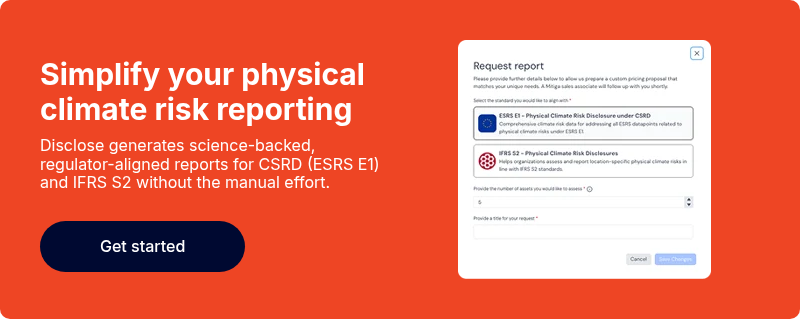
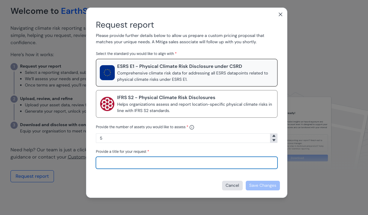
For companies navigating complex reporting requirements under CSRD, IFRS, and related standards, EarthScan supports built-in regulatory workflows through Disclose.
It provides:
- Pre-built CSRD (ESRS E1) and IFRS (IFRS S2) templates aligned with Article 15 (physical risk datapoints)
- Instant Excel and PDF reports that map hazard exposure, probabilities, return periods, and materiality flags directly into disclosure-ready files
- Support for physical risk scoring across all covered hazards
- Customisable outputs allowing consultants or in-house teams to tailor reports for boards, investors, auditors, or regulators
- Significant time savings by removing the need to manually map raw model outputs into CSRD frameworks
This automation allows sustainability teams, consultants, financial institutions, and asset managers to move from analysis to disclosure swiftly, without spending days or weeks building custom reporting templates.
Disclose eliminates one of the biggest barriers in disclosure preparation turning complex climate risk data directly into regulator-ready, audit-friendly reports.
How Jupiter compares
Jupiter positions itself as regulatory-ready for enterprise clients, but takes a different approach:
- Offers strong CSRD hazard coverage breadth (claiming coverage of ~27 of 33 CSRD hazard datapoints), though exact reporting field mapping is not publicly disclosed
- Does not generate automated, pre-formatted disclosure reports for CSRD, ISSB, or TCFD out of the box
- Provides detailed raw outputs and financial impact metrics that can feed into disclosures, but require additional processing and reporting assembly by the client or via consulting partners
- Integrates with enterprise reporting systems (e.g. PowerBI, Excel, MRM) — useful for sophisticated in-house teams but adds complexity for smaller organisations
For many organisations, especially those with limited internal climate expertise, Jupiter’s reporting support may require additional tooling or consulting engagement to achieve regulator-ready filings.
7. Commercial model and pricing flexibility
The way climate risk platforms structure pricing, contracts, and scalability can make a major difference depending on whether you’re running a small pilot, scaling across hundreds of assets, or integrating into enterprise systems.
How EarthScan approaches it
EarthScan offers flexible pricing models that adapt to different client sizes, from smaller consultancies to large institutional investors:
- No minimum contract value — clients can start with small portfolios and scale as needed
- Pricing is per asset, with clear volume-based discounts for larger portfolios
- API access is discounted for clients integrating EarthScan into existing platforms or partner systems
- Modular products (e.g. EarthScan Disclose) can be added as standalone features depending on reporting needs
- Transparent quotes and free trial access help clients validate the platform before committing
This structure supports consulting firms, infrastructure operators, investment teams, and sustainability teams who want to start small, scale up quickly, or test regulatory workflows without committing to large enterprise-style contracts.
EarthScan’s pricing flexibility is particularly helpful for organisations testing early CSRD pilots or rapidly growing portfolios.
How Jupiter compares
Jupiter follows a traditional enterprise pricing model, typically geared toward large financial institutions and enterprise clients:
- Pricing is based on asset volumes and portfolio size, with tiered rates for larger deployments.
- SaaS portal and API access are bundled together as part of broader enterprise contracts (API-only pricing is not published separately).
- Consulting-led onboarding packages often accompany enterprise deployments, adding additional integration and configuration costs.
- Full pricing details are not publicly disclosed, with quotes provided directly during sales discussions based on each client’s portfolio scope and industry.
For large financial institutions or insurers with mature climate risk teams, this model may fit well. But for smaller firms, consultancies, or mid-sized clients, Jupiter’s pricing structure may present higher entry commitments and longer onboarding processes.
8. Platform speed and usability
When you’re evaluating climate risk platforms, speed matters, especially when you're trying to assess portfolios quickly, meet disclosure deadlines, or respond to due diligence requests.
A platform that delays uploads or forces workarounds can add real cost and friction to your risk workflows.
How EarthScan approaches it
EarthScan is built for fast, self-serve access. Users can upload asset lists via CSV or select from over 500M pre-mapped global assets, enabling instant evaluations without manual data entry.
Insights are generated in seconds, with intuitive filtering by scenario, return period, and hazard type. Asset-level reports, summary outputs, and disclosure-ready files can be exported instantly in Excel or PDF formats.
For example, infrastructure investors use EarthScan to screen portfolios across multiple geographies, comparing exposure across hazards, timeframes, and, where supported, financial risk indicators like CVaR. All of this is done within a single dashboard, with no need for external consultants.

How Jupiter compares
Jupiter ClimateScore Global offers a SaaS portal and enterprise API access, with deeper onboarding and configuration typically supported by consulting or enterprise service teams.
Portfolio assessments can be configured for large-scale exposure analysis, but onboarding and deployment often require enterprise agreements, internal data harmonisation, and external onboarding packages.
Bulk upload functionality is available, but the platform has less emphasis on fully self-serve, browser-based reporting and automation.
This model may work well for large financial institutions integrating climate risk directly into enterprise systems, but can introduce longer lead times for smaller teams needing rapid, ad-hoc analysis.
Which one to choose: EarthScan or Jupiter?
Both EarthScan and Jupiter provide climate risk analytics, but depending on your priorities, their approaches serve different business needs.
Choose EarthScan if you’re looking for:
- Asset-level insights built for decisions
Designed for real estate, infrastructure, and financial portfolios where risk data supports investment, operational planning, and reporting — not just financial stress tests.
- Regulatory reporting you can generate instantly
EarthScan Disclose maps risk directly to CSRD, IFRS, and TCFD fields — with Excel/PDF reports ready for auditors, regulators, and boards.
- Transparent science and quantified uncertainty
Uses Mitiga’s Multiple Futures Model, CMIP6 climate data, CORDEX downscaling, and 5th–95th percentile confidence intervals to show not just risk levels, but uncertainty ranges.
- Customisable risk horizons, not just fixed averages
Supports full control over return periods — from 2 to 1,000 years — to model both frequent events and extreme tail risks.
- Financial impact modelling where science supports it
CVaR outputs for acute hazards (flooding, wind) based on established damage curves; avoids oversimplifying risks where credible financial models don’t exist.
- Global scale, simple onboarding
Assess any location worldwide, with 500M+ pre-mapped assets, self-service uploads, and immediate platform access — no lengthy enterprise onboarding.
- Built-in tools that simplify complex datasets
Includes flood maps, hail exposure layers, energy demand index (for heating and cooling loads), and composite scoring for cross-portfolio comparisons.
- Flexible pricing without enterprise lock-in
No minimum contract value. Scale pricing based on assets, with discounted API options for enterprise data integrations.
Choose Jupiter if you’re looking for:
- Enterprise-level financial stress testing
Delivers financial impact metrics across OpEx, CapEx, revenue loss, credit profile, market valuation, and developing credit risk models.
- Chronic adaptation cost modelling
Estimates productivity losses, water costs, chronic heat operational impacts, and adaptation ROI for chronic risks.
- Enterprise system integration
API deployments, PowerBI visualisation support, and partner-led onboarding for large financial institutions with in-house climate risk teams.
- Custom high-resolution modelling
High-resolution modelling for flood, wildfire, and wind (down to 1–3 metres) available via enterprise projects.
- Enterprise contracting structure
Designed for large banks, insurers, and global corporates with complex procurement needs.
Final words
Choosing a climate risk platform isn’t just about comparing model features. It’s about whether you can trust how risk is calculated, explain it to stakeholders, and act on it confidently.
EarthScan and Jupiter approach these challenges differently. EarthScan focuses on delivering decision-ready outputs for asset managers, infrastructure operators, and financial institutions who need transparent, regulator-aligned insights.
The platform’s science is fully documented, uncertainty ranges are visible, and risk calculations are traceable, avoiding the black-box outputs that can create challenges when presenting to auditors or regulators.
Jupiter offers broader financial stress-testing models across multiple business dimensions, often integrated into enterprise systems for large banking and insurance clients, but this approach may require additional onboarding, consulting, and internal modelling expertise to adapt outputs into fully audit-ready reporting.
If you're actively comparing options, you can start a free trial to explore EarthScan using your portfolio data and see results in minutes. Or book a demo with our team to walk through EarthScan’s outputs, disclosures, and reporting features in your business context.
